Feet Of Snow Will Bury West Coast This Week
Active weather pattern expected next week. The jet stream in the eastern Pacific is going to strengthen next week bringing strong storms to the west coast. The most likely time for impacts in the Sierra Nevada will be the end of next week, between Wednesday Dec. 9th and Friday Dec. 11th. It is too far out to project the exact impacts from these storms, but right now it looks like the Sierra may see very strong winds and rain/snow for the second half of next week.
We’ve already posted about the expected dumpage that’s heading for California and the rest of the West Coast this week. The active weather pattern producing what the National Weather Service is calling the strongest storm of the season.
From US National Weather Service Reno Nevada:
The jet stream in the eastern Pacific is going to strengthen next week bringing strong storms to the west coast. The most likely time for impacts in the Sierra Nevada will be the end of next week, between Wednesday Dec. 9th and Friday Dec. 11th.
It is too far out to project the exact impacts from these storms, but right now it looks like the Sierra may see very strong winds and rain/snow for the second half of next week.
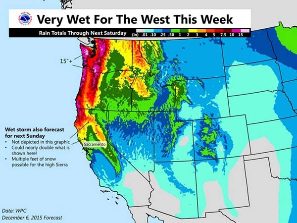
In places like Mt Baker, WA, over 15 inches of rain is expected, but in the form of snowfall that’s over 100″ of snow. We’re talking pounds baby pounds!
All we can say is that this is the storm we’ve been praying for for over two years. Please Lord, make it real and not just imaginary!
[efb_likebox fanpage_url=https://www.facebook.com/ActionSportsDaily fb_appid=”OPTIONAL_SEE_FAQ” box_width=275 box_height=40 responsive=1 show_faces=0 show_stream=0 hide_cover=1 small_header=1 hide_cta=1 locale=default en_US]